- copy")
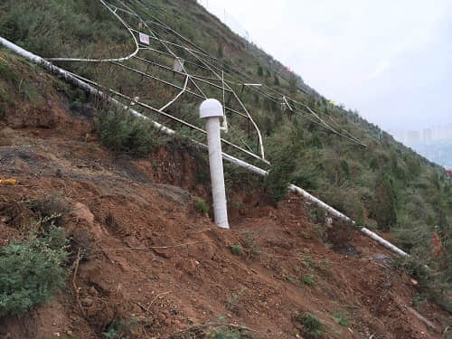
7moon29Wang Mingming, the head of the company's technical department, led the technical team to Xining City, Qinghai Province, to carry out the installation and commissioning of the automated monitoring and early warning system for the deformation of the landslide body on the west slope of Xining Nanshan.
The western exit of the Nanshan Tunnel is located halfway up the western slope of Nanshan, at the design elevation of2294.86m, the terrain is high in the east and low in the west, and the slopes are steep and difficult to walk on. In the past decades, landslides have occurred many times on the western slopes of Nanshan, causing casualties among the people and property losses.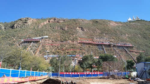
Artificial monitoring due to the influence and limitations of climate, environment, monitoring time and other factors, can not be monitored at night, wind and rain and ice and snow and other extreme conditions, it will leave a gap in the monitoring time period, and therefore can not be real-time monitoring of landslides in a timely manner, and can not be timely prediction of the trend of landslide deformation and timely early warning, and the occurrence of geologic hazards of landslides are often generated in extreme climatic conditions, coupled with the monitoring of the Long cycle time (5years), the labor intensity is very high. In order to ensure the safety of the surrounding buildings and people's lives and properties during the through construction of the Nanshan Tunnel, it is necessary to carry out automated deformation monitoring of the landslide body on the west slope of Nanshan, and to analyze the data in real time with daily reporting, so as to ensure that the competent authorities can understand the movement and deformation of the landslide body in a timely manner every day.
The Automated Geohazard Monitoring System (AGMS) is a system that integrates currentGNSSHigh-precision positioning technology, wireless communication technology, database technology,GNSSThe latest technological achievements, such as communication technology, have developed a set of comprehensive systems applicable to the automated monitoring of geologic hazards, which are capable of real-time monitoring of monitoring objects and forecasting and analyzing the results of the monitoring in order to assist in decision-making.


 Su Gong Network Security No. 32011202000665