Skip to content
  - copy")
 System Advantages

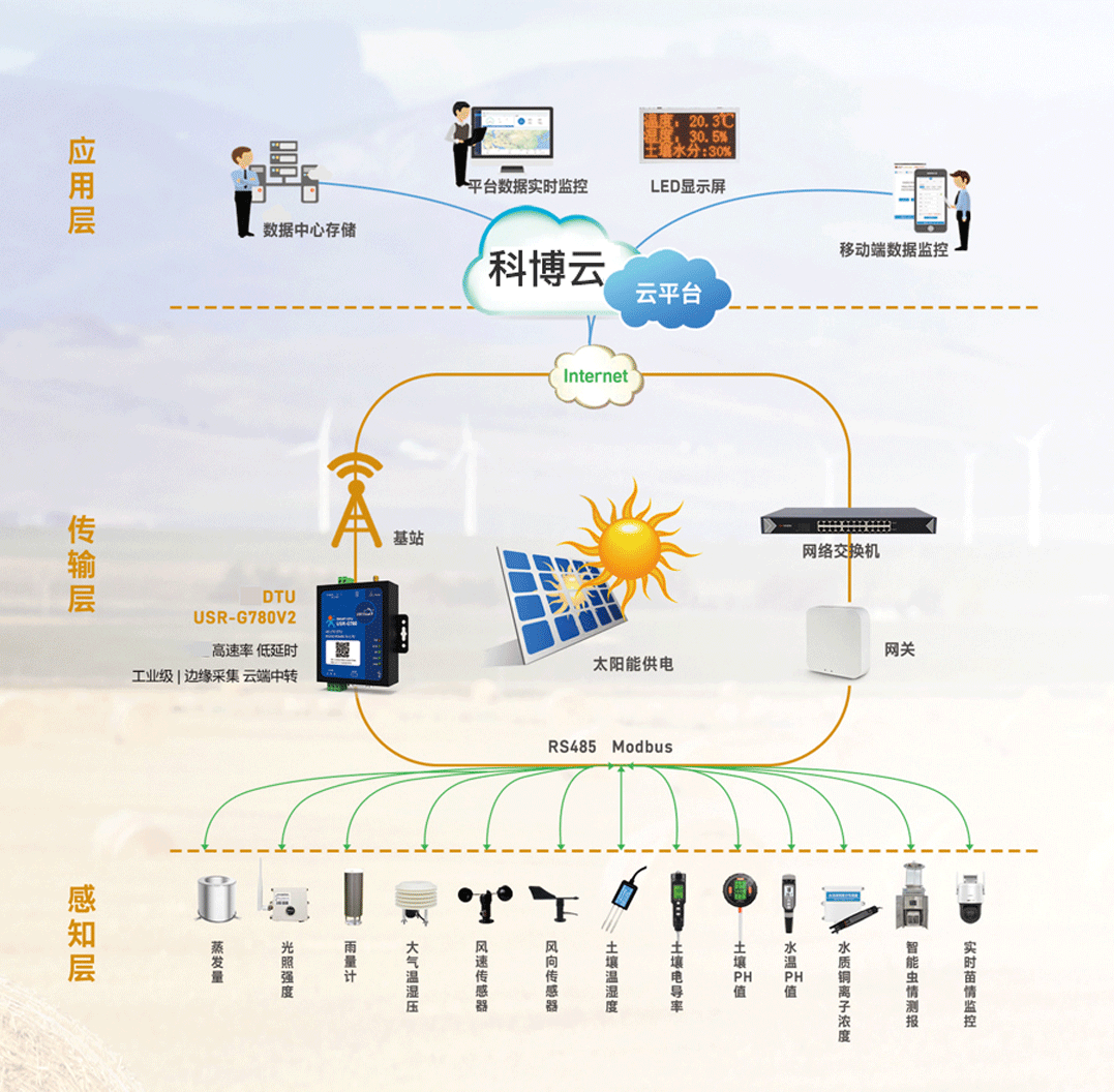
Information sharing/one map
depend onInformation technology, visualization techniques,GISTechnology and other agricultural data resources and geographic information data in the region, the formation of various types of local agricultural resources and key industry data to create a series of agricultural data"shot"The company's goal is to visualize and analyze agricultural data in a holistic manner.

GIS and Agricultural Cloud Mapping
Through high-precision satellite GIS, information on key agricultural bases within the geographic area will be in theGISReal-time display on the map, through the color block to distinguish land types, planting crop types and other important information, to achieve automatic statistics and other functions, you can understand the key agricultural profile of the entire county, to achieve direct control of the region's agriculture, to guide the macro-development of agriculture.

Meteorological monitoring
Accurate weather forecasts and climate change predictions can be provided through accurate observation of weather, climate and atmospheric information.

Sense and Control
Environmental microsensors andNB-IoTIoT communication technologies, andAIArtificial intelligence and remote expert digital diagnosis and control of the system to achieve water, soil, fertilizer and medicine closed loop and intelligent control of plant growth process.
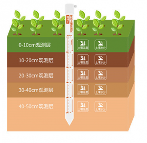
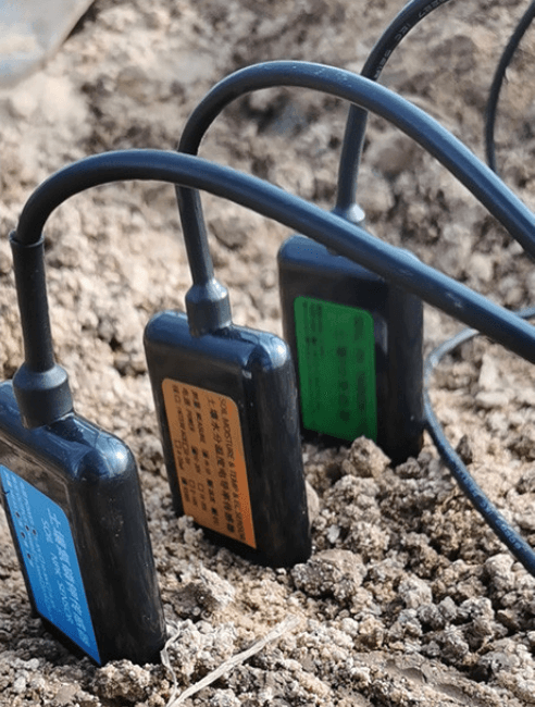
Monitoring elements
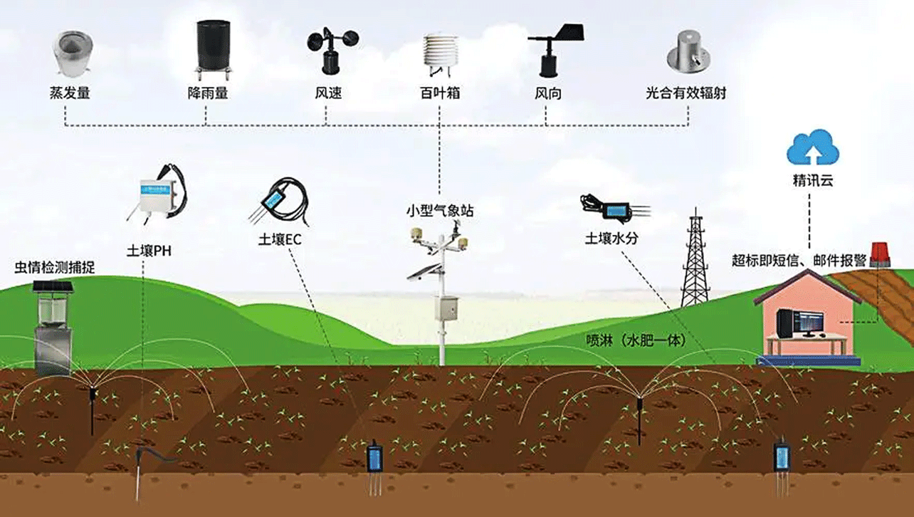
Monitoring Principles
Rainfall automated monitoring using tipping bucket rain gauge sensor for monitoring. Rainwater is collected by the water receiver - through the water inlet valve - into the water storage room - the water level rises - the float rises - the sensor reads the data - the microcomputer control circuit output passive pulse.
- Monitoring equipment
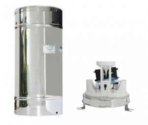
The technical parameters are as follows:
- Rainbow caliber: 200±0.6mm
- Resolution: 2mm;
- Rain intensity range: 01 to 4mm/min (Allowed to pass the maximum rain intensity of 8mm/min);
- Measurement accuracy: ≤±4%
- Working environment: temperature: -10 ~ +50 ℃, the relative humidity of the air is unlimited
- BER: less than 10-4
- Reliability index: MTBF ≥25000 hours
- The rain gauge has a good ability to adapt to outdoor working conditions and should be protected against rust, corrosion, blocking and insects.
Monitoring Principles
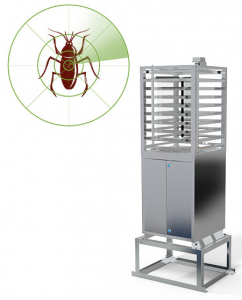
Remote control of insect conditions in the field, pollution-free trapping and killing of insects
Automatic pest monitoring system mainly uses modern light, electricity, CNC technology wireless transmission technology, Internet technology to build a set of pest ecological monitoring and early-warning system which integrates pest trapping and photographing, environmental information collection and data transmission, data analysis in one, and realizes the automation and intelligence of pest trapping, classification and statistics, real time transmission, remote detection, pest early warning and control guidance. With stable performance, easy operation and flexible settings, it is widely used in the fields of agriculture, forestry and animal husbandry, vegetables, tobacco, tea, medicinal herbs, gardens, orchards, urban greening and quarantine.
- Monitoring equipment
Monitoring Principles
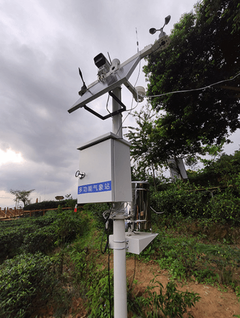
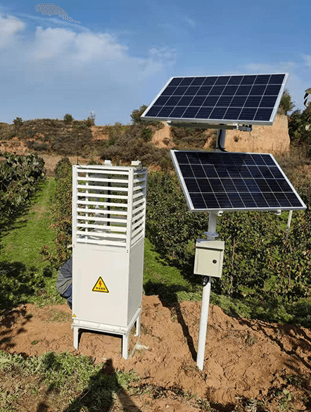
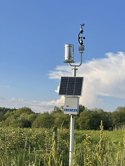
Real-time monitoring of farm weather and timely forecasting of extreme weather conditions
Monitoring elements: air temperature, air humidity, UV intensity, total solar radiation, wind speed, wind direction, wind force, rainfall, and insect monitoring captures.
Agricultural environmental monitoring, through on-site meteorological equipment, can be carried out in real time within the agricultural scene. It improves the ability of agricultural production to cope with natural environmental risks and turns vulnerable traditional agriculture into a modern industry with high efficiency.
Monitoring Principles
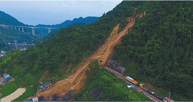
Precise monitoring of soil wall conditions and rapid early warning of anomalies
The soil wall condition monitoring system can realize all-weather uninterrupted monitoring. The on-site remote monitoring equipment automatically collects real-time data on soil wall conditions and realizes remote transmission of data by using GPRS wireless network: the monitoring center automatically receives and automatically stores the monitoring data of each monitoring point into the database.
Monitoring Principles
Utilizing the open channel technology, the flow rate is obtained by measuring the height of the fluid level based on the flow rate-level transport algorithm, combined with the geometry of the standard weir, side slope coefficients, channel accuracy, hydraulic ramps, and correction factors for the vertical plane of the flow rate, and then by the microprocessor operation inside the instrument.
Monitoring equipment
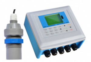
The technical parameters are as follows:
- Measuring range: 1m
- Blind spot: 06m
- Ranging accuracy: ±1mm-±25%F.S
- Material: ABS, reinforced PP
- Mounting ports: 5
- Protection class: IP65
- Working environment: -40 ~ +85℃
- Display: Chinese 3-inch LCD
- Keys: 18-bit keyboard operation
- Electrical Interface: 5-5
- Power supply: AC220V or DC12~24V power supply
- Power consumption: 5W
- Protection class: IP65
- Working environment: -40 ~ +85℃
- Signal input: RS485
- Monitoring Principles
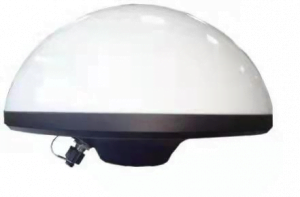
Cameras are deployed in important areas such as the upstream water feet of each reservoir. With the help of video AI technology, it realizes flood discharge monitoring, reservoir water level monitoring, and reservoir engineering management. Based on artificial intelligence image recognition technology, through deep learning algorithms, it automatically extracts, locates and analyzes specific scenes and behaviors appearing in the video monitoring, automatically identifies the scenes and illegal and unauthorized contents in the front-end video streaming data, such as trespassing by illegal people, illegal swimming, etc., and timely carries out intelligent early warning, remediation instructions are automatically sent by outbound call, so as to improve the efficiency of manual supervision and costs. Adopting cloud inspection method to seamlessly connect with the existing artificial intelligent inspection to improve and enhance the traditional manual inspection work mode.
- Monitoring equipment
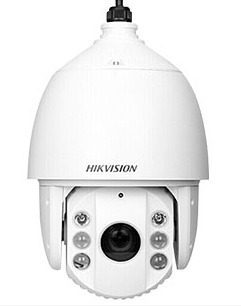
The technical parameters are as follows.
- Minimum illumination: Color: 005 Lux @ (F1.5, AGC ON), B/W: 0.001 Lux @ (F1.5, AGC ON), 0 lux with IR
- Focal length: 5.9~-177 mm; 30X optical zoom
- Field of view: 57.4°~2.3° (wide-angle~telephoto)
- Infrared irradiation distance: 150 m
- Horizontal range: Horizontal 360° Vertical range: -15°~90° (auto flip)
- Horizontal speed: Horizontal keying speed: 1°~160°/s, speed settable; Horizontal preset point speed: 240°/s Vertical speed: Vertical keying speed: 1°~120°/s, speed settable; Vertical preset point speed: 200°/s
- Main stream frame rate resolution: 50 Hz: 25 fps (2560 × 1440); 60 Hz: 24 fps (2560 × 1440)
- Video Compression Standard: H.265, 264, MJPEG
- Network Storage: NAS (NFS, SMB/CIFS)
- Network interface: RJ45 network port, adaptive 10 M/100 M network data
Working Principle
Early warning broadcasting equipment is based on 4G public network, providing users with multi-functional wireless early warning broadcasting services. High-fidelity power amplifier: strong, clear and bright sound quality, strong directivity, wide spread, even in a vast area, many obstacles in the environment, is still clear spread
Site Features
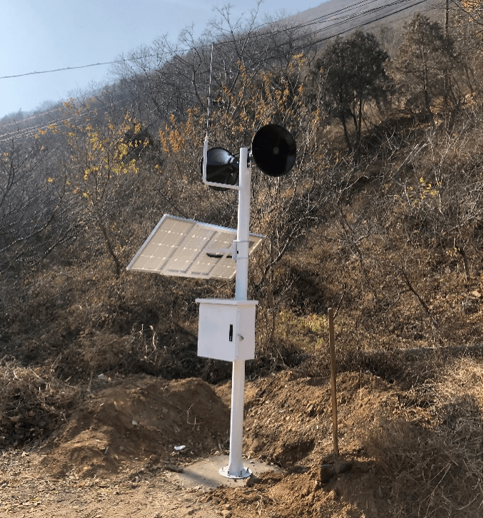
- Real-time, timed, and periodic notification shouts
- Mobile APP, 4G microphone emergency remote shouting
- Automatic shouting for intruder sensing
- Short message alarms, voice alarms, local microphone shouting alarms
Monitoring Principles
Rainfall automated monitoring using tipping bucket rain gauge sensor for monitoring. Rainwater is collected by the water receiver - through the water inlet valve - into the water storage room - the water level rises - the float rises - the sensor reads the data - the microcomputer control circuit output passive pulse.
Monitoring equipment
The technical parameters are as follows:
Rainbow caliber: 200±0.6mm
Resolution: 2mm;
Rain intensity range: 01 to 4mm/min (Allowed to pass the maximum rain intensity of 8mm/min);
Measurement accuracy: ≤±4%
Working environment: temperature: -10 ~ +50 ℃, the relative humidity of the air is unlimited
BER: less than 10-4
Reliability index: MTBF ≥25000 hours
The rain gauge has a good ability to adapt to outdoor working conditions and should be protected against rust, corrosion, blocking and insects.
Monitoring equipment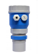
The technical parameters are as follows:
Measuring range: 0~70m
Resolution: 1cm
Measurement accuracy: ±1cm
Display: OLED Chinese and English
Measuring time: ≤20s
Beam angle: ≤12°
Power supply: 6VDC~28VDC
Monitoring Principles
This system adopts BeiDou automated monitoring method to monitor the surface displacement of the monitoring area for automated deformation monitoring, and its working principle is as follows: each BeiDou monitoring point and reference point receiver receives BeiDou signals in real time and sends them to the control center in real time through the data communication network, and the BeiDou data processing software of the server of the control center decodes the three-dimensional coordinates of each monitoring point, and the data analysis module acquires the three-dimensional coordinates of each monitoring point and compares them with the initial coordinates to obtain the amount of change of the monitoring point. The data analysis module acquires the three-dimensional coordinates of each monitoring point and compares them with the initial coordinates to obtain the amount of change of the monitoring point, and at the same time, the analysis software alarms according to the pre-set warning value.
Monitoring equipment
The technical parameters are as follows:
Observed parameters BDS B1, B2
gps l1 c/a, l2 e, l2 c, l5
GLONASS L1 C/A, L2 C/A
positioning accuracy
Level 2.5mm+1ppm RMS
Vertical 5mm+1ppm RMS
Environmental parameters Positioning time Cold start<45S
Hot start 30S Initialization reliability >99.9%
Operating temperature -40˚C to +75˚C Recapture time <2S
Supply voltage 9 to 36 (V) DC Storage temperature -55˚C to +85˚C
Mechanical shock MIL810D, ±40g Baud rate 2400 to 460800
Humidity 99% non-condensing Power consumption <3.5W
Monitoring Principles
The vibrating string type seepage manometer is buried for a long time in the hydraulic structure or other concrete structure and soil body, measuring the structure or soil body inside the infiltration (pore) water pressure, calculating the water level through the measured water pressure, and can be synchronized with the measurement of the temperature of the buried point. Seepage manometer with supporting accessories can be used in the pressure measurement pipeline, foundation drilling.
Monitoring equipment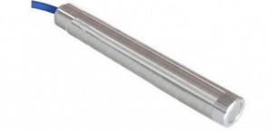
The technical parameters are as follows:
Measuring range: 0 to 7MPa
Resolution: ≤ 025%F.
Fitting accuracy: ≈ 1%F.S/0.5%F.S
Temperature measurement range: -40℃~+85℃.
Sensitivity: ±1 °C
Output signal: Hz
Water pressure resistance: 2 times the measuring range
Insulation resistance: ≥50MΩ
Monitoring Principles
Utilizing the open channel technology, the flow rate is obtained by measuring the height of the fluid level based on the flow rate-level transport algorithm, combined with the geometry of the standard weir, side slope coefficients, channel accuracy, hydraulic ramps, and correction factors for the vertical plane of the flow rate, and then by the microprocessor operation inside the instrument.
Monitoring equipment
The technical parameters are as follows:
Measuring range: 1m
Blind spot: 06m
Ranging accuracy: ±1mm-±25%F.S
Material: ABS, reinforced PP
Mounting ports: 5
Protection class: IP65
Working environment: -40 ~ +85℃
Display: Chinese 3-inch LCD
Keys: 18-bit keyboard operation
Electrical Interface: 5-5
Power supply: AC220V or DC12~24V power supply
Power consumption: 5W
Protection class: IP65
Working environment: -40 ~ +85℃
Signal input: RS485
Monitoring Principles
In the process of concrete hardening, due to concrete dehydration, caused by contraction, or by the temperature difference between high and low temperatures, causing uneven expansion and contraction and cracks. In civil engineering quality inspection often use the seam gauge (seam gauge) for monitoring, seam gauge (seam gauge) is suitable for long-term buried in hydraulic buildings or other concrete buildings or the surface, measurement of structural expansion joints or peripheral joints opening and closing (deformation), and can be synchronized with the measurement of the temperature of the buried point. It can be equipped with accessories to form bedrock variometer, surface crack meter, multi-point variometer and other instruments for measuring deformation.
Monitoring equipment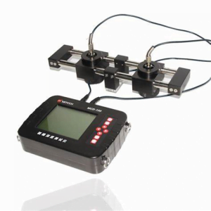
The technical parameters are as follows:
Displacement range (m): ≤3m
Displacement accuracy (mm): 1
Measuring range (m): 50
Tilt angle range: ±90
Angular accuracy: 1
Working temperature: -40~85℃
Sampling interval: 1~500
Monitoring Principles
Stress gauge (stress gauge) is an instrument to measure the ground stress. According to the ground stress measurement in the sensor used in different stiffness, the sensor can be divided into two kinds: if the stiffness than the measured location of the rock's stiffness, known as the stress gauge; if less than the measured area of the rock's stiffness, it is called deformation gauge or strain gauge. Because the stress gauge stiffness, has a great ability to resist the deformation of the rock, and the pressure itself depends mainly on the stress in the rock, and the elastic constants of the rock has little relationship, the greater the stiffness of this effect is more pronounced, and therefore it is not necessary to accurately determine the elastic constants of the rock when measuring.
Monitoring equipment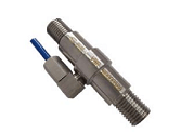
The technical parameters are as follows:
Standard range: 400Mpa
Nonlinearity: ≤0.5%F.S.
Sensitivity: ±1mm-±25%F.S
Endurance: 24 hours of uninterrupted monitoring
Communication capability: based on 4G/5G communication, data transmission delay is less than 10ms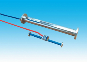
The technical parameters are as follows:
Standard range: ±1500με
Measuring standard: 150mm
Sensitivity: 1με (1Hz)
Working Temperature: -10℃~70℃
Communication capability: based on 4G/5G communication, data transmission delay is less than 10ms
Monitoring Principles
Cameras are deployed in important areas such as the upstream water feet of each reservoir. With the help of video AI technology, it realizes flood discharge monitoring, reservoir water level monitoring, and reservoir engineering management. Based on artificial intelligence image recognition technology, through deep learning algorithms, it automatically extracts, locates and analyzes specific scenes and behaviors appearing in the video monitoring, automatically identifies the scenes and illegal and unauthorized contents in the front-end video streaming data, such as trespassing by illegal people, illegal swimming, etc., and timely carries out intelligent early warning, remediation instructions are automatically sent by outbound call, so as to improve the efficiency of manual supervision and costs. Adopting cloud inspection method to seamlessly connect with the existing artificial intelligent inspection to improve and enhance the traditional manual inspection work mode.
Monitoring equipment
The technical parameters are as follows.
Minimum illumination: Color: 005 Lux @ (F1.5, AGC ON), B/W: 0.001 Lux @ (F1.5, AGC ON), 0 lux with IR
Focal length: 5.9~-177 mm; 30X optical zoom
Field of view: 57.4°~2.3° (wide-angle~telephoto)
Infrared irradiation distance: 150 m
Horizontal range: Horizontal 360° Vertical range: -15°~90° (auto flip)
Horizontal speed: Horizontal keying speed: 1°~160°/s, speed settable; Horizontal preset point speed: 240°/s Vertical speed: Vertical keying speed: 1°~120°/s, speed settable; Vertical preset point speed: 200°/s
Main stream frame rate resolution: 50 Hz: 25 fps (2560 × 1440); 60 Hz: 24 fps (2560 × 1440)
Video Compression Standard: H.265, 264, MJPEG
Network Storage: NAS (NFS, SMB/CIFS)
Network interface: RJ45 network port, adaptive 10 M/100 M network data
Working Principle
Early warning broadcasting equipment is based on 4G public network, providing users with multi-functional wireless early warning broadcasting services. High-fidelity power amplifier: strong, clear and bright sound quality, strong directivity, wide spread, even in a vast area, many obstacles in the environment, is still clear spread
Site Features
Real-time, timed, and periodic notification shouts
Mobile APP, 4G microphone emergency remote shouting
Automatic shouting for intruder sensing
Short message alarms, voice alarms, local microphone shouting alarms
Solution Architecture
Project Cases
Other solutions


Company Profile
Ltd. was founded in 2012 in Nanjing by Nanjing science and technology innovation and entrepreneurship leader, relying on Nanjing University of Information Engineering, Anhui University of Science and Technology, Hohai University and other industry colleges and universities of advanced science and technology, high-level talent and other advantageous resources, is the government, industry, academia and research closely integrated with the national high-tech, dual-soft certified enterprises, with the qualification of surveying and mapping, through the ISO9001 quality The company has passed ISO9001 quality management system certification. The company focuses on meteorology and water conservancy, intelligent mining, intelligent road and bridge, natural disasters, resources and environment, public security monitoring and early warning areas, adhering to the concept of "precision, specialization, integration, and specialization", and advocating the spirit of "stopping at excellence", to provide excellent technical solutions, system integration, and high-end platforms for the government, enterprises and public institutions. We provide excellent technical solutions, system integration and high-end platform services for governments, enterprises and public institutions. The company set up branches or offices in Nanchang, Xi'an, Guiyang, Wuxi, service radiation in East China, Central China, Northwest China, Southwest China market, for the relevant departments of provinces and cities to provide high-quality, high-quality pre-sales and after-sales service.
The company insists on independent innovation, independently researched and developed safety monitoring and early warning systems for reservoirs, tailing ponds, pylons, slopes, bridges, etc., and provided supporting equipment systems and technical support for major events such as the 2016 Hangzhou G20 Summit and the 2018 Qingdao SCO Summit for many times, and the core products have passed the testing of national professional institutions, and the key technologies have been authorized by patents. The company owns and is authorized to use more than 30 patents, and has registered more than 20 software copyrights. Its scientific research achievements and system products have won a number of awards, such as the Second Prize of China's Satellite Navigation and Positioning Scientific and Technological Advancement, the First Prize of Shaanxi Province's Surveying, Mapping and Geoinformation Scientific and Technological Advancement, the Second Prize of Jiangsu Province's Surveying, Mapping and Geoinformation Scientific and Technological Advancement, and the Third Prize of Anhui Provincial Science and Technology Award. The company has established cooperative relationship with more than 100 units including government departments, listed companies, provincial and municipal industrial institutions, etc. The system products and technologies are widely used in more than 300 projects in 18 provinces such as Jiangsu, Anhui, Beijing, Hubei, Hunan, Yunnan, Shandong, Guizhou, Zhejiang, Qinghai, Inner Mongolia, Fujian, Jiangxi, Guangdong, etc., which have been highly affirmed by the user units and government departments. Many media, such as Jiangsu Provincial News Network, Nanjing TV, Xining TV and so on, have reported on the company in all aspects.
The company actively strengthens the cooperation and contact with universities, and is now the postgraduate training base of Nanjing University of Information Engineering, Nanjing University of Technology, the practice base of postgraduate students of Anhui University of Science and Technology, and has been recognized as a double unit of Remote Sensing and Surveying and Mapping Engineering School of Nanjing University of Information Engineering, and with Wuhan University, the Chinese Academy of Sciences, the China University of Mining and Technology, Southeast University, Hohai University, the University of New South Wales in Australia, and other domestic and foreign famous universities to establish close cooperative relations. We have established close cooperation relationship with famous universities in China and abroad, such as Wuhan University, Chinese Academy of Sciences, China University of Mining and Technology, Southeast University, Hohai University and University of New South Wales, Australia. Team members have been awarded the title of "Six Talent Peaks" high-level talents in Jiangsu Province, Advanced Individuals in Nanjing Innovation and Entrepreneurship Competition, Nanjing May 1st Labor Medal, Top Ten Scientific and Technological Youths in Surveying, Mapping and Geographic Information of Jiangsu Province, etc. Provincial and municipal leaders such as the then Secretary of CPC Youth League Committee of Jiangsu Province, Mr. Wang Wei, have visited our company for many times, and have guided our work, and we have also received a number of awards from Nanjing TV, Xining TV, Xining Net TV, and Nanjing TV. Nanjing TV station, Xining TV station, NetEase and other media have reported the team's achievements many times, which is highly recognized by the society and the government.
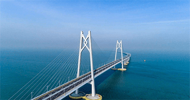
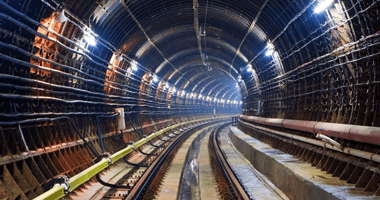
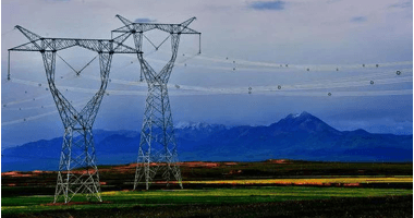
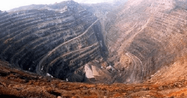
Application scope of the system platform: safety monitoring and early warning of reservoirs, smart mines, river dams, landslides, tailing ponds, slopes, coal mine subsidence zones, bridges, indoor and outdoor safety of commercial complexes, electric power, telecommunication pylons, high-rise buildings, dangerous houses, high-speed railroads' safe operation, subway tunnels, and so on.
Regional coverage: Jiangsu, Anhui, Beijing, Hubei, Hunan, Yunnan, Shandong, Guizhou, Zhejiang, Qinghai, Inner Mongolia, Fujian, Jiangxi and other 20 provinces, more than 300 projects.
Customer-centered, integrity-based, pragmatic as a source of unity as the basis for cohesion and development!
Our Philosophy
☆ Scientific and technological innovation: conceptual innovation as the forerunner, strategic innovation as the direction, organizational innovation as the guarantee, scientific and technological innovation as the means, market innovation as the goal
☆ Strive for Entrepreneurship: Weaving Dreams with Tenacity, Casting Brilliance with Action
☆ Integrity and Pragmatism: Integrity as the foundation and pragmatism as the source.
☆ Solidarity and collaboration: solidarity as the basis for cohesive efforts to seek development
☆Adhering to the development concepts of "Prioritizing Talent", "Specialization, Newness, and Specialty", and "Achieving the Best".
☆Adhering to the market competition strategy of "providing high-end knowledge services with a focus on customers".
☆Integration of resources such as "talents, universities, industries, and capital" to enhance the benefits of market transformation.
☆Always adhering to the "driving force of innovation" to achieve sustainable development


 Su Gong Network Security No. 32011202000665